Youtube video fallback image

RonnebyTrails

Seven routes and twelve village loops through ancient woodland, Bronze Age history and the quiet river valleys of Blekinge

RonnebySlingor is a network of walking and cycling routes connecting forest, lakes and villages around Ronneby. Seven trails and twelve village loops - from a thirty-minute stroll to a seventy-kilometre cycling journey - all open year-round, all leading somewhere worth going.


WHAT YOU WILL FIND ALONG THE WAY

Ancient landscape, quiet roads, living history

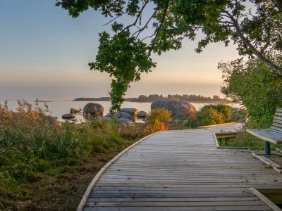
The routes follow Ronnebyån river through its valley, pass through stands of ancient broadleaf forest and cross open agricultural land that has barely changed in a thousand years. Along the way, interpretive signs explain the nature, history and local stories of the places you are moving through - so a walk becomes something more than exercise.

  1. Ancient broadleaf forest - Old-growth woodland - oak, beech and ash - that takes decades to earn its atmosphere.
  2. Rivers & lakes - The Ronnebyån and Bräkneån valleys define the landscape. Clear water, swimming spots and the sound of moving rivers.
  3. Bronze Age cairns - Three-thousand-year-old burial mounds in the open landscape. Still standing. Still worth stopping for.
  4. Villages & working farms - Small communities that have been here long enough to have their own loop named after them.

Seven trails that take you back to the start — and leave you wanting to go again, from a different direction. - RonnebySlingor, Blekinge

THE SEVEN TRAILS

Choose your route


1. Bräkneleden

CYKLING • 70 KM

A 70-kilometre cycling route along the Bräkneån river, designed to be ridden in stages. Two alignments to choose from: the northern route takes you through dramatic cultural landscapes shaped by the Ice Age and more recent industrial history; the southern route follows a flatter Iron Age landscape all the way to the coastal village of Järnavik, where a ferry crosses to the island of Tjärö.


2. Blekinge's longest gravel road

CYKLING

Between Hjorthålan and Jakobstorp, along two connecting gravel roads. Halfway, Bredasjön - a beautiful swimming lake with a barbecue area - offers a natural pause. The terrain around Gröngölsmåla is pleasingly hilly, with the kinds of climbs that earn their descent. Along the way: dry-stone walls, unusual rock formations and the particular quietness of a road very few people know about.


3. A journey through time

WALKING & CYKLING

A circular route that begins and ends at Naturum. The trail moves through Ronneby town centre, up a steep climb at Djupafors and into the forest, where the Anglestue shelter is a good stop for a packed lunch. From there, gravel roads and dry-stone walls lead through nature reserves and past Bronze Age cairns, down to Ronneby harbour, before climbing back to Ronneby Brunn.

Note: the section between Silverforsen and Kallinge centre is closed to motor vehicles.


4. Gribshundsleden

WALKING & CYKLING

Named after the Gribshunden — a 15th-century Danish warship whose wreck lies just offshore. The route passes the site of the shipwreck, continues to Saxemara nature park for swimming and barbecuing, visits an old boatyard, and follows the coast to Bussevik, where there is overnight shelter and a place to sit with a thermos.

Note: a temporary reroute is in place due to forestry work and new construction along part of the route.

5. Karlsnäsleden

WALKING & CYKLING

Following the Ronnebyån valley from Ronneby town square through Kallinge to Karlsnäs, this trail combines industrial heritage, stories of earlier generations' daily lives and genuine natural beauty. At Karlsnäsgården there is swimming, a barbecue area and several shorter walking loops to extend the day.


6. Tusenårsresan - the thousand-year journey

CYKLING • FLEXIBLE ROUTE

Choose your own alignment through some of Blekinge's most remarkable places. The route takes in Ronneby's historic town centre, the ancient estate of Johannishus, significant nature reserves and a stretch of unspoiled coastline. Legend-haunted sites alternate with quiet refuges. The kind of route where you will find yourself stopping more often than you planned.


7. Vildmarksleden - the wilderness trail

WALKING, CYKLING & HORSE RIDING

Walk, cycle or ride through quiet forest with clear lakes and the Bräkneån river running alongside. The trail connects Nordensköldsparken in Eringsboda to Svenmanska parken in Bräkne-Hoby — park to park through shifting nature with abundant wildlife, rushing water, old mills and the kind of stories that attach themselves to places over centuries. Fishing permits available via the iFiske app or ifiske.se.

Note: the river crossing at Klåvben, south of Hjorthålan, is currently closed.


TWELVE VILLAGE LOOPS · 0.8–5 km

Shorter walks, from Belganet to Järnavik

Twelve compact loops, each rooted in a specific village or landscape. Short enough to fit before lunch, substantial enough to feel like a proper walk.


Guided audio walks

Download the app via Google Play or the App Store to access guided walks with audio commentary along the RonnebySlingor routes. A map and live trail information are also available in the app.