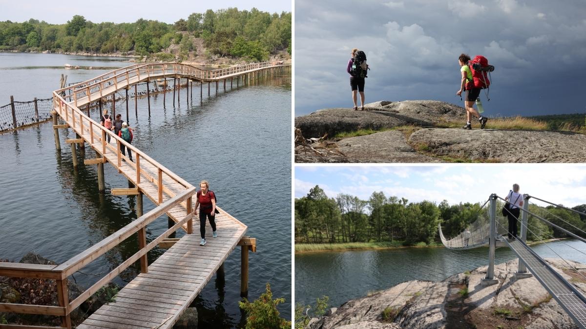
Eriksbergsledens hängbro, Blekinge

Eriksbergsleden – come closer to Blekinge’s wild coast

Eriksbergsleden is a demanding coastal hike in Blekinge, Sweden, for those who want to come closer – to nature, stillness and their own pace. The trail is 12 kilometres long, runs between Eriksberg Outdoor and Björnahemmet, and is not a circular route. Along the way, cliffs, forest and sea decide the rhythm.

Eriksbergsleden Blekinge


Quick facts

  • Length: approx. 12 km
  • Trail type: One-way (not circular)
  • Difficulty: Very demanding
  • Terrain: Rocky slabs, slippery stones, narrow paths
  • Area: Eriksbergs Stränder Nature Reserve, Blekinge Archipelago
  • Suitable for: Experienced hikers only

Selected filters:

Blekinge’s most demanding hiking trail – on nature’s terms

Eriksbergsleden is often described as the toughest hiking trail in Blekinge. Not because it seeks to impress, but because it requires presence and responsibility. What makes the trail demanding:

  • Highly varied terrain with cliffs, stones and technical passages
  • Long distance without services – you must carry all food and water
  • Remote location, where rescue access can be limited in case of an accident

This hike is intended for well-prepared, experienced hikers who respect the landscape and their own limits.

Eriksbergsleden Blekinge
Eriksbergsleden – en krävande kustvandring där Blekinges vildare landskap, stillhet och närhet till naturen sätter tempot.


A coastal hike that slows you down

In 2025, Alböleleden and Kohageleden were joined to form Eriksbergsleden – a continuous coastal trail shaped by the landscape rather than efficiency.

There are no shortcuts here. Only time, sea air and the quiet pull of the archipelago.

Overnight shelters along the trail

There are two shelters along Eriksbergsleden. One of them can be booked in advance.

Övernatta i ett värn vid Eriskbergsleden


Booking a shelter

  • Price: 300 SEK
  • Booking via ark56.se
  • When booked, you have exclusive access to the shelter

Book overnight stay via ARK56


Access code

The access code is provided in your booking confirmation email via the green link “Start booking”.

The code becomes available only at your booked time and is not the booking reference number.


Camping along Eriksbergsleden

Camping is allowed within Eriksbergs Stränder Nature Reserve at designated spots, including:

  • Bruksviken
  • Dragsö

Keep it simple. Leave the place as you would wish to find it.

Eriksbergsleden i Blekinge - lummig grönskande miljö

Safety and responsibility

Hiking Eriksbergsleden means taking responsibility for yourself and others.

Always bring:

  • First aid and necessary medication
  • Sufficient food and water
  • Fully charged mobile phone

In case of emergency, use the 112 app so emergency services can locate you via GPS.

Getting here – and beyond

Parking is available at:

Public transport:

Blekingetrafikens Local Traffic


Between start and finish

  • Cycling between entrances: approx. 10.6 km
  • Alternative route available in the Hittaut app


GPX and navigation

GPX file available for download. For mobile navigation, we recommend:

Download GPX


Get close to nature in Blekinge

Stay overnight in a shelter and 

FAQ – Eriksbergsleden

What is Eriksbergsleden?

Eriksbergsleden is a coastal hiking trail in Blekinge, Sweden. It was created in 2025 by connecting the former Alböleleden and Kohageleden into one continuous route. The trail is approximately 12 kilometres long and runs between Eriksberg Outdoor and Björnahemmet. Please note that Eriksbergsleden is not a circular route.

Why is Eriksbergsleden considered the most demanding hike in Blekinge?

Eriksbergsleden is regarded as Blekinge’s most demanding hiking trail due to:

  • Highly varied terrain with rocky slabs, slippery stones, stone walls and narrow paths
  • A long stretch without services, requiring you to carry your own food and water
  • Limited access for emergency services in case of an accident

The trail is suitable only for experienced hikers with good physical fitness and confidence in challenging terrain.

Is Eriksbergsleden safe to hike?

Yes – but it requires careful preparation. Always bring:

  • Sufficient water and energy
  • First aid and any necessary medication
  • A fully charged mobile phone

In case of an accident, emergency services may have difficulty reaching the area. We strongly recommend using the 112 app, which allows emergency operators to see your GPS location.

Are there overnight shelters along the trail?

Yes. There are two shelters along Eriksbergsleden, one of which can be booked in advance.

How do I book the shelter?

The bookable shelter costs SEK 300 and is booked via:
👉 www.ark56.se

When you book, you are guaranteed a place and have exclusive access to the shelter.

Where do I find the access code for the shelter?

The access code is included in your booking confirmation email. Click the green link labelled “Start booking” to view the code.

  • The code becomes available only at your booked time
  • If you click too early, you will see the message “You are early…”
  • The code is not your booking reference, but an eight-digit access code
What facilities are available in the shelter?

The shelter is designed as a simple wind shelter and includes:

  • Wooden sleeping platforms for 6–8 people
  • Steel doors that can be opened
  • A stove (firewood included in the bookable shelter)

A toilet is located near the water – follow the signs.
⚠️ The terrain between the shelter and the shore is steep. Use the stairs along the trail.

No drinking water is available on site.

What responsibilities apply when staying in the shelter?

The shelters and Eriksbergsleden are part of the Blekinge Archipelago Biosphere Area, an area with high natural value.

You are responsible for:

  • Cleaning the shelter after your stay
  • Taking all rubbish with you
  • Closing and locking the doors
  • Reattaching and locking the padlock

Leave the place as you would like to find it.

Is camping allowed along Eriksbergsleden?

Yes. Camping is permitted within Eriksbergs Stränder Nature Reserve at designated sites, including:

  • Bruksviken
  • Dragsö
How do I get to Eriksbergsleden and where can I park?

Parking is available at:

  • Eriksberg Outdoor
  • Björnahemmet

If the car park at Björnahemmet is full, additional parking is available in Matvik.

Can I reach the trail by public transport?

Yes. You can use Blekingetrafiken’s on-demand transport (Närtrafik) to reach both the start and end points of the trail.

What rules apply in the nature reserve?

Eriksbergsleden runs through Eriksbergs Stränder Nature Reserve. Current regulations are provided by the County Administrative Board:
👉 Read the rules here

How do I get between the start and end points?

Cycling between the trailheads is possible and covers approximately 10.6 km. Please note that parts of the route follow trafficked roads.

  • You can also walk around the entire Eriksberg area, but the northern section (approx. 6 km) is not marked on the ground.

The route is available in the Hittaut app.

Is there a GPX file for Eriksbergsleden?

Yes. A GPX file is available on ark56.se. Go to the Eriksbergsleden page and scroll down to “Download GPX”.

Which apps are recommended?

For navigation and inspiration, we recommend:

  • ARK56 app
  • Naturkartan
Contact and further information

Questions about bookings:
team@ark56.se

Fault reporting (shelters or trail):
naturforvaltning.blekinge@lansstyrelsen.se

Welcome to Eriksbergsleden, ARK56 and the Blekinge Archipelago.