Vandra på öarna, nå lederna med kollektivtrafiken.
Vandra på öarna i Blekinge. Nå lederna med kollektivtrafiken.
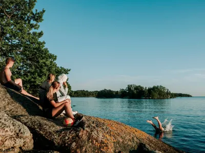
Vandring på Tjärö i Blekinge. Foto av Niklas Kämpargård.

Car-free hiking in Blekinge by bus, train and boat

Some of Blekinge’s most rewarding walks can be reached without a car. Travel by train, bus or archipelago boat to islands, coastal paths, beech forests and nature reserves – and make the journey part of your day out.


Choose your walk

Destination Travel Best for
Hanö Bus and boat Island walks, cliffs and sea views
Torhamns udde Bus and walk Coastal meadows and birdwatching
Tjärö Bus and boat or archipelago boat Short island trails and swimming
Blekingeleden at Östafors Bus Full-day hikes and simple overnight stays
Laxaleden Train and bus A linear walk beside the Mörrum River
Svalemålaleden Pre-booked rural bus and walk


Plan before travelling: Timetables, stops and boat services change during the year. Always check the complete journey with Blekingetrafiken and confirm current boat departures before setting out. 

Plan your journey with Blekingetrafiken →
 

Hanö

An island walk with cliffs, a lighthouse and open sea views

Travel to the fishing village of Nogersund, then take the boat across Hanö Bay. Paths lead through grassland, deciduous woodland and across rocky ground with wide views of the Baltic Sea.

The white trail passes several of the island’s best-known places. Some sections are uneven, so wear shoes with good grip and allow plenty of time.

Distance: The white trail is approximately 4.3 kilometres.

Getting there: Travel to Sölvesborg, then continue by bus to Nogersund harbour. Boats to Hanö leave from the harbour, with services varying by season.

Stay: Hanö Vandrarhem provides accommodation on the island. Check opening dates and availability directly.


Torhamns udde

Walk among coastal meadows and abundant birdlife

Torhamns udde offers open coastal meadows, grazing land and views across the sea. The nature reserve is internationally recognised as an important birdwatching site. Large numbers of migratory birds pass through the area, particularly in spring and autumn.

Bring binoculars and keep your distance from birds and grazing animals. Dogs and other pets must be kept on a lead. Do not pitch a tent or park a caravan without permission from the landowner or reserve manager.

Distance: Use the nature reserve map to choose a walk that suits you. Remember to include the distance between the bus stop and the reserve.

Getting there: Search for a journey to the Torhamn bus stop. The stop is approximately one kilometre north of the nature reserve. From Torhamn Church, follow the road south.

Good to know: Facilities include an information board, toilet, designated fire area and birdwatching tower.


Tjärö

Short trails through a traditional archipelago landscape

The trails on Tjärö pass through oak pastures, grazing land, deciduous woodland and across smooth coastal rocks. The island is small enough to explore on foot in a day, while accommodation is available if you would like to stay longer.

Livestock graze on the island during summer. Keep your distance, close gates behind you and keep dogs on a lead. Camping is permitted for one night in the designated camping area.

Distance: Tjärö has several marked trails, including routes of approximately 1.5, 1.6 and 3 kilometres. Check the latest map and trail markings before your visit.

Getting there: Seasonal boat services operate from Järnavik and Karlshamn, among other departure points. Parts of the journey to Järnavik may require demand-responsive transport that must be booked in advance.

Stay: Tjärö offers rooms, cottages and a designated camping area. Availability and opening times vary by season.


Blekingeleden at Östafors

Walk towards Grundsjön or Halen

Blekingeleden and Skåneleden meet near the Holjeån river at Östafors. From here, you can walk south towards Grundsjön or north through the forest landscape towards Lake Halen and Olofström.

Both routes are best suited to full-day hikes. The terrain is hilly and can be demanding. A wind shelter and designated fire area are available at Östafors.

Distance: The route between Grundsjön and Östafors is approximately 15.8 kilometres. The route between Östafors and Halen is approximately 15.5 kilometres. Distances may change when trails are rerouted.

Current trail information: Parts of the trail west of Östafors may be rerouted or have incomplete waymarking. Check the latest route information in Naturkartan immediately before setting off.

Getting there: Search for a bus journey to Östafors. For a point-to-point hike, remember to check the return journey from Olofström, Grundsjön or your chosen finishing point.

Stay: Overnight stays are possible at campsites along the trail. Check current rules and information about drinking water and facilities before setting off.


Laxaleden

Follow the Mörrum River between Svängsta and Mörrum

Laxaleden follows the Mörrum River through deciduous woodland, cultural landscapes and places that tell the story of fishing and industry along the river.

The section between Svängsta and Mörrum works well as a point-to-point walk, as you can combine bus and train travel.

Some parts of the trail are narrow, rocky and steep. Check the map and choose a section suited to your group’s experience and ability.

Distance: The section between Svängsta and Mörrum is approximately 12 kilometres. The entire Laxaleden trail is around 30 kilometres and runs between Elleholm and Hovmansbygd.

Getting there: Take the bus to Svängsta and walk towards Mörrum, where you can continue your journey by train. Alternatively, take the train to Mörrum and walk north towards Svängsta.

Stay: Mörrums Kronolaxfiske offers accommodation close to the river and trail, including hostel rooms, camping pitches and motorhome spaces.


Svalemålaleden 

A coastal walk between Järnavik and Gyö 

Svalemålaleden passes through beech woodland, grazing land and coastal scenery overlooking Järnavik and the archipelago. The circular route returns you to your starting point. 

The terrain varies between country roads, gravel tracks and woodland paths. Some sections can be steep, wet or difficult to follow. Keep the digital map available throughout your walk. 

Distance: The complete circular trail is approximately 6.3 kilometres. Shorter alternatives can be created by choosing a different turning point. 

Getting there: Search for a journey to Järnavik. Parts of the journey may require demand-responsive transport and advance booking. Check booking requirements and departure times with Blekingetrafiken. 

Stay: Several accommodation options are available in and around Järnavik and Svalemåla. Check current availability and seasonal opening times before booking.


Plan a safe walk

  • Check both your outward and return journeys before setting off.
  • Book demand-responsive transport well in advance.
  • Check the dates and times of seasonal boat services.
  • Download a map or GPX file before entering areas with limited mobile coverage.
  • Bring water, food and clothing suited to the weather.
  • Follow nature reserve regulations and keep dogs on a lead where required.
  • Light fires only in designated areas and check the current fire-risk level.
  • Tell someone which route you intend to walk.
  • Plan your walk from the first stop

Choose a trail, check the latest map and plan your complete journey before setting off.

Find buses, trains and boats with Blekingetrafiken→

Discover more hiking trails in Blekinge →